


Everything You Need to Know About Independence Pass
Independence Pass is a part of Colorado State Highway 82, that passes over the Continental Divide between Leadville and Aspen, Colorado.
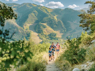
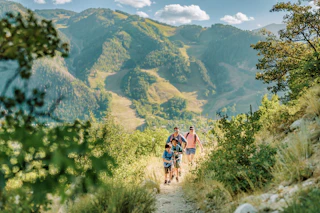
The summit of the Continental Divide is 12,095 feet above sea level. It is about 32 miles long and takes anywhere from 45 minutes to an hour-and-a-half with stops along the way. Independence Pass is among the most scenic drives with spectacular mountain views and lookout spots. The road winds around groves of aspen and above alpine valleys as the Roaring Fork River rushes nearby. Whether hiking, biking, exploring Independence Ghost Town, or driving to your next destination, there are plenty of ways to enjoy Independence Pass.

Know Before You Go: Independence Pass closes for the winter season and is typically open from late May to late October. The road is steep, narrow, and twisty with only a few guardrails. While it's safe, drivers must follow the speed limit, stay alert, and drive with caution. Be sure to check the weather prior to traveling and stay up to date on road conditions. Commercial and recreational vehicles 35-feet or longer are prohibited on Independence Pass- check out alternative routes on I-70.

Cycling: Road biking on Independence Pass/Highway 82 is a popular route during late spring, summer, and early fall.
The road climbs to the Continental Divide at the top of the Pass (12,095 ft.). In late spring, after the snow melts and before the road opens to vehicles for the season, bikers can enjoy a peaceful ride without cars. Just before the road opens to cars for the season, cyclists can participate in Ride for the Pass, an annual 10 mile ride that begins near the winter closure gate and finishes at Independence Ghost Town. When the road is open to vehicles, typically from mid-late May to late October, be alert to car traffic, which is especially heavy on summer weekends. The road is extremely narrow in some sections, making it important to stay aware and prioritize safety. It is about 20 miles from Aspen to the peak of the Pass, but cyclists can turn around at any point and ride back to town.

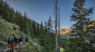
Hiking trails: There are several trails to enjoy right off of the Pass ranging from easy to difficult depending on your interests and ability. Below are a few top picks:
- Discovery Trail (easy) This is an easy dog friendly trail that is a 0.3 gravel mile loop following the bank of the Roaring Fork River. It is located adjacent to the Braille Trail an easy 0.2 mile dirt loop that includes signage in Braille and is accessible for anyone. Both trails are meant to provide easy access to the wilderness for all that enjoy nature.
- Weller Lake Trail (moderate) Travel about 8 miles up Independence Pass from Aspen to the Weller Lake Trailhead. This short hike meanders through pine forests until it reaches Weller Lake, which is surrounded by boulders and pines with mountains in the distance.
- Difficult Creek Trail (moderate) The Difficult Creek Trail begins about 5 miles from downtown Aspen at Difficult Campground, a popular camping spot. The trail has a bridge the crosses over the Roaring Fork River before climbing through stands of aspen and pines and traveling near Difficult Creek. While it is lengthy at 8.3+ miles out and back, hikers can turn around at any time.
- Lost Man Trail (moderate - difficult) The Upper Lost Man Trailhead begins near the top of Independence Pass, around 18 miles from downtown Aspen. The trail ascends through alpine meadows interspersed with boulders and wildflowers, a landscape unlike many other trails, which pass through forests and greenery. At a high elevation, the wildflowers on Lost Man Trail are in full bloom later in the summer. The trail passes Independence Lake before making a final climb to Lost Man Lake. If you’re up for a much longer, more challenging hike at 8.8+ miles, the lower Lost Man trailhead connects to the upper Lost Man trailhead. Avoid walking on the narrow and busy Independence Pass road by parking a car at each trailhead if you choose this route. For a complete list of trails near Independence Pass, check out Aspen Trail Finder.
Camping: Reservations are often required for campsites. Camping on the Aspen side of Independence Pass is available at Difficult Campground, Weller Campground, Lincoln Gulch and Lost Man Campground.

Additional attractions:
Independence Ghost Town About 16 miles east of Aspen is the historic ghost town of Independence. Independence was the first mining site in the Roaring Fork Valley, discovered in 1879. Today you can view the remains of miner's cabins, the Farewell Stamp Mill, Stables, and the General Store.
Continental Divide: The midway point between Aspen and Twin Lakes Colorado, the Pass is on the border between the Pitkin and Lake Counties, while serving as the dividing point between watersheds that drain into the Pacific Ocean vs. those that drain into the Atlantic Ocean. At 12,095 ft, the weather can be unpredictable so bring layers. There is ample parking and a scenic overlook near the pass where you can take in the 360-degree views.
Grottos Ice Caves: About 9 miles from Aspen, the Grottos Trail is great for picnicking and exploring the waterfalls, rock formations and ice caves.

Environmental Information:
Independence Pass corridor is home to a range of flora and fauna and passes through three major life zones: the montane, subalpine, and alpine. From vibrant greenery alongside the Roaring Fork River to the alpine, windblown tundra at the summit, Independence Pass has diverse environments that we strive to preserve and protect for all to experience in the years to come.
The Independence Pass Foundation works to restore and protect the ecological, historical, and aesthetic integrity of the Independence Pass corridor and encourages safety, stewardship, and appreciation of the Pass. Sign up to give back and volunteer with the Independence Pass Foundation.
Commit to protecting the environment by signing the Aspen Pledge. With each signature of the Aspen Pledge, ACRA will donate $18.80, in honor of the year Aspen was incorporated, to either the Independence Pass Foundation or Roaring Fork Outdoor Volunteers.
When exploring, follow the Care for Colorado Leave No Trace Principles to give others the chance to experience its natural beauty. Tag us on social @AspenCo in your adventures on Independence Pass!